
Make a donation
Gear up for your next adventure:
As an Amazon Associate, this site earns from qualifying purchases at no extra cost to you.
Glittertinden topographic map
Click on the map to display elevation.
Make a donation
Gear up for your next adventure:
As an Amazon Associate, this site earns from qualifying purchases at no extra cost to you.
Glittertinden
The mountain reaches an elevation of 2,465 metres (8,087 ft) above sea level, including the glacier on top of its peak, but without the glacier, the mountain reaches 2,452 metres (8,045 ft). Glittertind had earlier been a challenger for the title as the highest mountain in Norway, as measurements showed Glittertind including the glacier was slightly higher than Galdhøpiggen which reaches an elevation of 2,469 metres (8,100 ft) above sea level with no glacier at the summit. In a 1917 official map, the mountain was indicated to be 2,481 metres (8,140 ft). So it was a matter of defining a glacier as a part of a mountain or not. The glacier has, however, shrunk in recent years, and the dispute has been settled in Galdhøpiggen's favour. The summit of Glittertind was reached for the first time in 1841 by Harald Nicolai Storm Wergeland and Hans Sletten.
Make a donation
Gear up for your next adventure:
As an Amazon Associate, this site earns from qualifying purchases at no extra cost to you.
About this map
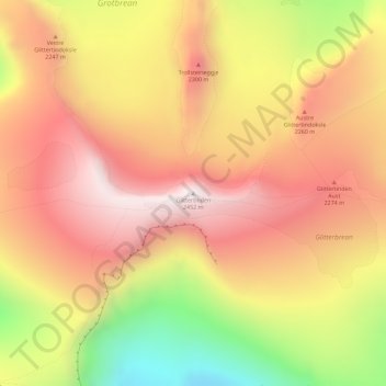
Name: Glittertinden topographic map, elevation, terrain.
Location: Glittertinden, Lom, Innlandet, Norway (61.65134 8.55773 61.65144 8.55783)
Average elevation: 6,998 ft
Minimum elevation: 5,420 ft
Maximum elevation: 8,051 ft
Make a donation
Gear up for your next adventure:
As an Amazon Associate, this site earns from qualifying purchases at no extra cost to you.