
Thank you for supporting this site ❤️
Make a donation
Make a donation
Gear up for your next adventure:
As an Amazon Associate, this site earns from qualifying purchases at no extra cost to you.
Xares topographic map
Click on the map to display elevation.
Thank you for supporting this site ❤️
Make a donation
Make a donation
Gear up for your next adventure:
As an Amazon Associate, this site earns from qualifying purchases at no extra cost to you.
About this map
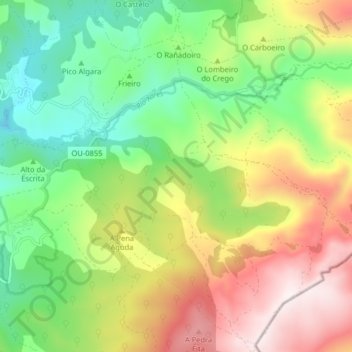
Name: Xares topographic map, elevation, terrain.
Location: Xares, A Veiga, Valdeorras, Orense, Galicia, 32365, España (42.20738 -6.95012 42.26444 -6.86986)
Average elevation: 4,177 ft
Minimum elevation: 3,051 ft
Maximum elevation: 5,771 ft
Thank you for supporting this site ❤️
Make a donation
Make a donation
Gear up for your next adventure:
As an Amazon Associate, this site earns from qualifying purchases at no extra cost to you.