Geolocate

East Ridge topographic map

Click on the map to display elevation.

About this map

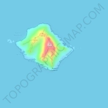
Name: East Ridge topographic map, elevation, terrain.

Location: East Ridge, Sabanetas, Mayagüez, Puerto Rico, United States (18.37950 -67.47918 18.38464 -67.47793)

Average elevation: 30 ft

Minimum elevation: 0 ft

Maximum elevation: 600 ft

Puerto Rico trails, hiking, mountain biking, running and outdoor activities

Gear up for your next adventure:

Camping Coffee Makers - Enjoy premium coffee at the summit or campsite
Backpacking Tent - Lightweight and durable tent for multi‑day hikes
🚪Portable Camp Chair - Foldable chair for comfort at camp
🔊Portable Camp Speaker - Music and alerts at camp
📡Handheld GPS Device - Reliable handheld GPS for outdoor navigation

As an Amazon Associate, this site earns from qualifying purchases at no extra cost to you.