
Thank you for supporting this site ❤️
Make a donation
Make a donation
Gear up for your next adventure:
As an Amazon Associate, this site earns from qualifying purchases at no extra cost to you.
Margudgued topographic map
Click on the map to display elevation.
Thank you for supporting this site ❤️
Make a donation
Make a donation
Gear up for your next adventure:
As an Amazon Associate, this site earns from qualifying purchases at no extra cost to you.
About this map
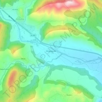
Name: Margudgued topographic map, elevation, terrain.
Location: Margudgued, Boltaña, Sobrarbe, Huesca, Aragón, 22340, España (42.41321 0.06452 42.45321 0.10452)
Average elevation: 2,198 ft
Minimum elevation: 1,811 ft
Maximum elevation: 3,130 ft
Thank you for supporting this site ❤️
Make a donation
Make a donation
Gear up for your next adventure:
As an Amazon Associate, this site earns from qualifying purchases at no extra cost to you.