
Thank you for supporting this site ❤️
Make a donation
Make a donation
Gear up for your next adventure:
As an Amazon Associate, this site earns from qualifying purchases at no extra cost to you.
Neskaupstaður topographic map
Click on the map to display elevation.
Thank you for supporting this site ❤️
Make a donation
Make a donation
Gear up for your next adventure:
As an Amazon Associate, this site earns from qualifying purchases at no extra cost to you.
About this map
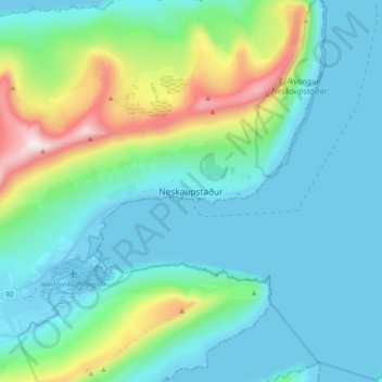
Name: Neskaupstaður topographic map, elevation, terrain.
Location: Neskaupstaður, Fjarðabyggð, Austurland, 740, Islande (65.10872 -13.72887 65.18872 -13.64887)
Average elevation: 564 ft
Minimum elevation: -13 ft
Maximum elevation: 2,907 ft
Thank you for supporting this site ❤️
Make a donation
Make a donation
Gear up for your next adventure:
As an Amazon Associate, this site earns from qualifying purchases at no extra cost to you.