Geolocate

Iba topographic map

Click on the map to display elevation.

About this map

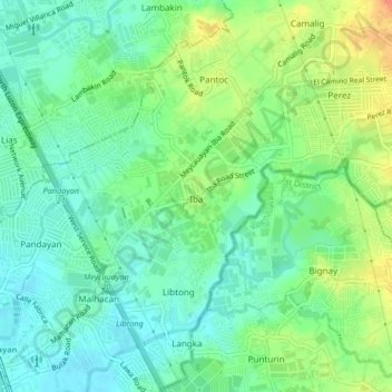
Name: Iba topographic map, elevation, terrain.

Location: Iba, Meycauayan, Bulacan, Central Luzon, 3020, Philippines (14.73451 120.96209 14.77451 121.00209)

Average elevation: 56 ft

Minimum elevation: 3 ft

Maximum elevation: 144 ft

Other topographic maps

Click on a map to view its topography, its elevation and its terrain.

Malhacan

Philippines > Bulacan > Meycauayan

Average elevation: 26 ft

Meycauayan River

Philippines > Bulacan > Meycauayan > Ubihan

Average elevation: 7 ft

Iba

Philippines > Bulacan > Meycauayan

Average elevation: 56 ft

Pajo

Philippines > Bulacan > Meycauayan

Average elevation: 102 ft

Ubihan

Philippines > Bulacan > Meycauayan

Average elevation: 10 ft

Banga

Philippines > Bulacan > Meycauayan

Average elevation: 13 ft

Malhacan

Philippines > Bulacan > Meycauayan

Average elevation: 26 ft

Bayugo

Philippines > Bulacan > Meycauayan

Average elevation: 13 ft

Saluysoy

Philippines > Bulacan > Meycauayan

Average elevation: 16 ft

Gear up for your next adventure:

🚁Photography Drones - Capture stunning aerial views of landforms and topography
📡Handheld GPS Device - Reliable handheld GPS for outdoor navigation
🗻Climbing Gear Basics - Essential gear for beginner climbers
🗃️Trail First Aid Kit - Essential kit for outdoor injuries and emergencies
🪑Ultralight Camp Chairs - Portable seating for resting after a long day of mapping

As an Amazon Associate, this site earns from qualifying purchases at no extra cost to you.