
Make a donation
Gear up for your next adventure:
As an Amazon Associate, this site earns from qualifying purchases at no extra cost to you.
Baconsthorpe topographic map
Click on the map to display elevation.
Make a donation
Gear up for your next adventure:
As an Amazon Associate, this site earns from qualifying purchases at no extra cost to you.
About this map
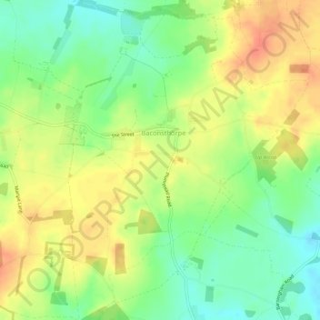
Name: Baconsthorpe topographic map, elevation, terrain.
Location: Baconsthorpe, North Norfolk, Norfolk, England, United Kingdom (52.87121 1.13807 52.90295 1.18176)
Average elevation: 249 ft
Minimum elevation: 174 ft
Maximum elevation: 318 ft
Make a donation
Gear up for your next adventure:
As an Amazon Associate, this site earns from qualifying purchases at no extra cost to you.
Other topographic maps
Click on a map to view its topography, its elevation and its terrain.
Beacon Hill
United Kingdom > England > Norfolk > North Norfolk
Beacon Hill is a part of the Cromer Ridge which is a ridge of old glacial moraines (terminal moraine) that stands next to the coast above Cromer. The Cromer Ridge seems to have been the front line of the ice sheet for some time at the last glaciations, which is shown by the large size of the feature. All the…
Average elevation: 213 ft
Make a donation
Gear up for your next adventure:
As an Amazon Associate, this site earns from qualifying purchases at no extra cost to you.
Stalham Green
United Kingdom > England > Norfolk > North Norfolk > Stalham Green
Average elevation: 16 ft
Johnson Street
United Kingdom > England > Norfolk > North Norfolk > Ludham > Johnson Street
Average elevation: 10 ft
Make a donation
Gear up for your next adventure:
As an Amazon Associate, this site earns from qualifying purchases at no extra cost to you.
The Eye
United Kingdom > England > Norfolk > North Norfolk > Cley next the Sea
Average elevation: 7 ft
Make a donation
Gear up for your next adventure:
As an Amazon Associate, this site earns from qualifying purchases at no extra cost to you.
North Walsham and Dilham Canal
United Kingdom > England > Norfolk > North Norfolk > Honing
Average elevation: 69 ft
Make a donation
Gear up for your next adventure:
As an Amazon Associate, this site earns from qualifying purchases at no extra cost to you.
Ridlington
United Kingdom > England > Norfolk > North Norfolk > Witton and Ridlington
Average elevation: 30 ft
Make a donation
Gear up for your next adventure:
As an Amazon Associate, this site earns from qualifying purchases at no extra cost to you.
Whimpwell Green
United Kingdom > England > Norfolk > North Norfolk > Happisburgh
Average elevation: 13 ft
Crowgate Street
United Kingdom > England > Norfolk > North Norfolk > Tunstead
Average elevation: 46 ft
Make a donation
Gear up for your next adventure:
As an Amazon Associate, this site earns from qualifying purchases at no extra cost to you.
Beeston Bump
United Kingdom > England > Norfolk > North Norfolk > Sheringham > Beeston Regis
Average elevation: 66 ft
Newgate
United Kingdom > England > Norfolk > North Norfolk > Cley next the Sea > Newgate
Average elevation: 72 ft
Make a donation
Gear up for your next adventure:
As an Amazon Associate, this site earns from qualifying purchases at no extra cost to you.
Bacton Green
United Kingdom > England > Norfolk > North Norfolk > Bacton > Bacton Green
Average elevation: 30 ft
West Raynham
United Kingdom > England > Norfolk > North Norfolk > West Raynham
Average elevation: 194 ft
Sheringham Park
United Kingdom > England > Norfolk > North Norfolk > Upper Sheringham
Average elevation: 200 ft
Make a donation
Gear up for your next adventure:
As an Amazon Associate, this site earns from qualifying purchases at no extra cost to you.