Geolocate

Kervédan topographic map

Interactive map

Click on the map to display elevation.

About this map

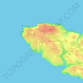
Name: Kervédan topographic map, elevation, terrain.

Location: Kervédan, Groix, Lorient, Morbihan, Bretagne, France métropolitaine, 56590, France (47.62441 -3.51985 47.66441 -3.47985)

Average elevation: 33 ft

Minimum elevation: 0 ft

Maximum elevation: 154 ft

Other topographic maps

Click on a map to view its topography, its elevation and its terrain.

Groix

France > Bretagne > Morbihan > Groix

Groix, Lorient, Morbihan, Bretagne, France métropolitaine, 56590, France

Average elevation: 26 ft

Le Méné

France > Bretagne > Morbihan > Groix > Le Méné

Le Méné, Groix, Lorient, Morbihan, Bretagne, France métropolitaine, 56590, France

Average elevation: 36 ft

Kerliet

France > Bretagne > Morbihan > Groix > Kerliet

Kerliet, Groix, Lorient, Morbihan, Bretagne, France métropolitaine, 56590, France

Average elevation: 43 ft

Kermoël

France > Bretagne > Morbihan > Groix

Kermoël, Groix, Lorient, Morbihan, Bretagne, France métropolitaine, 56590, France

Average elevation: 43 ft

Kerohet

France > Bretagne > Morbihan > Groix

Kerohet, Groix, Lorient, Morbihan, Bretagne, France métropolitaine, 56590, France

Average elevation: 20 ft

Camp des Vénètes

France > Bretagne > Morbihan > Groix > Kervédan

Camp des Vénètes, Route du Grand Phare, Kervédan, Groix, Lorient, Morbihan, Bretagne, France métropolitaine, 56590, France

Average elevation: 43 ft