Geolocate

Cashton topographic map

Click on the map to display elevation.

About this map

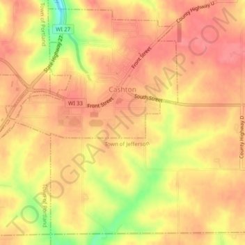
Name: Cashton topographic map, elevation, terrain.

Location: Cashton, Monroe County, Wisconsin, United States (43.72526 -90.80892 43.75101 -90.77063)

Average elevation: 1,332 ft

Minimum elevation: 1,168 ft

Maximum elevation: 1,394 ft

Monroe County trails, hiking, mountain biking, running and outdoor activities

Other topographic maps

Click on a map to view its topography, its elevation and its terrain.

Shennington

United States > Wisconsin > Monroe County

Average elevation: 912 ft

Gear up for your next adventure:

🪵Folding Camp Saw - Compact saw for wood and campsite work
🥘Titanium Cookware - Durable, featherlight pots and pans for backpacking
🧢Sun Protection Hats - Wide-brimmed and UPF-rated hats for high-altitude sun safety
🪶Camp Gear Gift Set - Perfect gift bundle for outdoor fans
🧣Hiking Neck Gaiter - Multi‑use neck protection for outdoor weather

As an Amazon Associate, this site earns from qualifying purchases at no extra cost to you.