Geolocate

Raanana topographic map

Click on the map to display elevation.

About this map

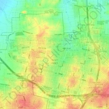
Name: Raanana topographic map, elevation, terrain.

Location: Raanana, Petah Tikva Subdistrict, Center District, Israel (32.16968 34.83677 32.20969 34.89126)

Average elevation: 161 ft

Minimum elevation: 52 ft

Maximum elevation: 266 ft

Other topographic maps

Click on a map to view its topography, its elevation and its terrain.

Zur Izhak

Israel > Center District

Average elevation: 276 ft

Kfar Saba

Israel > Center District

Average elevation: 177 ft

Lod

Israel > Center District

Average elevation: 200 ft

Tnuvot

Israel > Center District > Tnuvot

Average elevation: 128 ft

Hulda

Israel > Center District > Gezer Regional Council

Average elevation: 384 ft

Gear up for your next adventure:

🧢Outdoor Hiking Hat - Sun protection hat for outdoor explorers
🧣Merino Neck Gaiters - Multi-functional headwear for wind and sun protection
🌧️Backpack Rain Cover - Keep gear dry in wet weather
📱Solar Portable Charger - Solar power bank for charging devices off‑grid
🧯Portable Fire Pit - Compact fire pit for camping spots

As an Amazon Associate, this site earns from qualifying purchases at no extra cost to you.