Geolocate

Kfar Saba topographic map

Click on the map to display elevation.

About this map

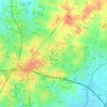
Name: Kfar Saba topographic map, elevation, terrain.

Location: Kfar Saba, Petah Tikva Subdistrict, Center District, Israel (32.15960 34.88507 32.20096 34.94396)

Average elevation: 177 ft

Minimum elevation: 89 ft

Maximum elevation: 282 ft

Other topographic maps

Click on a map to view its topography, its elevation and its terrain.

Modiin-Maccabim-Reut

Israel > Center District

הנחלים HaNechalim – The Rivers (Safdie) and משואה Masuah – Beacon (Givat C) are located towards the west of the city, and were planned by architect Moshe Safdie. Located in these neighborhoods are five commercial centers, a secondary school and three primary schools. The central street names are…

Average elevation: 653 ft

Yehud Monosson

Israel > Center District

Average elevation: 144 ft

Lod

Israel > Center District

Average elevation: 200 ft

Ramla

Israel > Center District

Average elevation: 246 ft

Shoham

Israel > Center District

Average elevation: 331 ft

Gedera

Israel > Center District

Average elevation: 184 ft

Lod

Israel > Center District

Average elevation: 194 ft

Raanana

Israel > Center District

Average elevation: 161 ft

Gan Yavne

Israel > Center District

Average elevation: 135 ft

Gear up for your next adventure:

🔭Telescopic Hiking Pole - Adjustable pole for hiking stability
🛶Inflatable Kayak - Portable kayak for rivers, lakes, and expeditions
👟Trail Running Shoes - Lightweight shoes for trail runners
🚪Portable Camp Chair - Foldable chair for comfort at camp
🗺️Topographic Maps - Detailed topo maps for hiking, exploring and outdoor navigation

As an Amazon Associate, this site earns from qualifying purchases at no extra cost to you.