
Elcetina topographic map
Click on the map to display elevation.
About this map
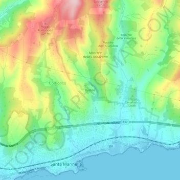
Name: Elcetina topographic map, elevation, terrain.
Location: Elcetina, Santa Marinella, Roma Capitale, Lazio, 00058, Italy (42.03189 11.85510 42.07189 11.89510)
Average elevation: 279 ft
Minimum elevation: -3 ft
Maximum elevation: 827 ft
Other topographic maps
Click on a map to view its topography, its elevation and its terrain.
Castello di Santa Severa
Italy > Lazio > Roma Capitale > Santa Marinella > Santa Severa
Average elevation: 16 ft