Geolocate

Norwalk topographic map

Click on the map to display elevation.

About this map

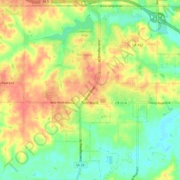
Name: Norwalk topographic map, elevation, terrain.

Location: Norwalk, Warren County, Iowa, 50211, United States (41.44638 -93.73197 41.51416 -93.64441)

Average elevation: 889 ft

Minimum elevation: 794 ft

Maximum elevation: 994 ft

Warren County trails, hiking, mountain biking, running and outdoor activities

Other topographic maps

Click on a map to view its topography, its elevation and its terrain.

Spring Hill

United States > Iowa > Warren County > Spring Hill

Average elevation: 869 ft

Ackworth

United States > Iowa > Warren County > Ackworth

Average elevation: 856 ft

Gear up for your next adventure:

🎒Gear Packing Cubes - Organize your backpack efficiently
🥤Water Filter Bottle - All‑in‑one filter bottle for safe hydration
🥾Men's Hiking Boots - Durable, waterproof footwear for rugged terrain and steep inclines
🍳Camping Cook Set - Complete cookware for outdoor meals
💧Water Purification System - Clean water on the trail with reliable purifiers

As an Amazon Associate, this site earns from qualifying purchases at no extra cost to you.