
Make a donation
Gear up for your next adventure:
As an Amazon Associate, this site earns from qualifying purchases at no extra cost to you.
Munugode topographic map
Click on the map to display elevation.
Make a donation
Gear up for your next adventure:
As an Amazon Associate, this site earns from qualifying purchases at no extra cost to you.
Munugode
Munungode is located at 17°04′00″N 79°04′00″E / 17.0667°N 79.0667°E / 17.0667; 79.0667.[2] It has an average elevation of 241 metres (793 ft).
Make a donation
Gear up for your next adventure:
As an Amazon Associate, this site earns from qualifying purchases at no extra cost to you.
About this map
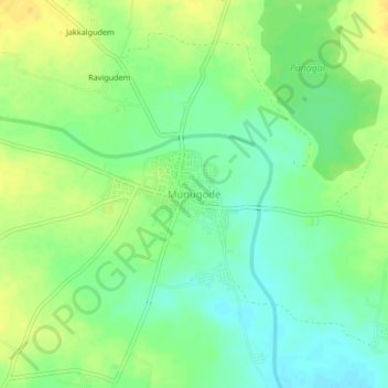
Name: Munugode topographic map, elevation, terrain.
Location: Munugode, Munugode mandal, Nalgonda, Telangana, 508244, India (17.05953 79.05667 17.09953 79.09667)
Average elevation: 823 ft
Minimum elevation: 781 ft
Maximum elevation: 866 ft
Make a donation
Gear up for your next adventure:
As an Amazon Associate, this site earns from qualifying purchases at no extra cost to you.