
Thank you for supporting this site ❤️
Make a donation
Make a donation
Gear up for your next adventure:
As an Amazon Associate, this site earns from qualifying purchases at no extra cost to you.
Blimbing topographic map
Click on the map to display elevation.
Thank you for supporting this site ❤️
Make a donation
Make a donation
Gear up for your next adventure:
As an Amazon Associate, this site earns from qualifying purchases at no extra cost to you.
About this map
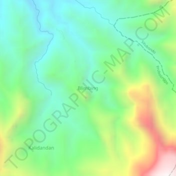
Name: Blimbing topographic map, elevation, terrain.
Location: Blimbing, Probolinggo, East Java, Indonesia (-7.83954 113.56622 -7.79954 113.60622)
Average elevation: 2,123 ft
Minimum elevation: 712 ft
Maximum elevation: 5,197 ft
Thank you for supporting this site ❤️
Make a donation
Make a donation
Gear up for your next adventure:
As an Amazon Associate, this site earns from qualifying purchases at no extra cost to you.