
Make a donation
Gear up for your next adventure:
As an Amazon Associate, this site earns from qualifying purchases at no extra cost to you.
Wadrill topographic map
Click on the map to display elevation.
Make a donation
Gear up for your next adventure:
As an Amazon Associate, this site earns from qualifying purchases at no extra cost to you.
Wadrill
Ein vermutlich aus der Zeit des Keltentums übernommener Brauch wird heute in Wadrill alljährlich zelebriert. Am ersten Fastensonntag wird von der Anhöhe des „Perscher Kopfes“ das so genannte „Erbsenrad“ in die Wadrill gerollt. Das Erbsenrad ist ein mit Stroh bzw. Heu umwickeltes Eisenrad. Das Stroh wird in Brand gesetzt und so den Berg hinunter gerollt, wo es schließlich in der Wadrill erlischt. Anschließend versammeln sich alle Beteiligten und Zuschauer in der Wadrilltalhalle zum traditionellen Eieressen. Dieser Brauch soll den ansässigen Bauern eine gute und ertragreiche Ernte verschaffen und den Frühling willkommen heißen.
Make a donation
Gear up for your next adventure:
As an Amazon Associate, this site earns from qualifying purchases at no extra cost to you.
About this map
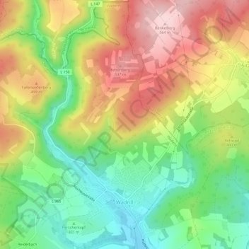
Name: Wadrill topographic map, elevation, terrain.
Location: Wadrill, Wadern, Landkreis Merzig-Wadern, Saarland, Deutschland (49.57644 6.84976 49.61303 6.90679)
Average elevation: 1,401 ft
Minimum elevation: 1,017 ft
Maximum elevation: 1,854 ft
Make a donation
Gear up for your next adventure:
As an Amazon Associate, this site earns from qualifying purchases at no extra cost to you.
Other topographic maps
Click on a map to view its topography, its elevation and its terrain.
Naturschutzgebiet Wadrilltal
Deutschland > Saarland > Landkreis Merzig-Wadern > Wadern
Average elevation: 1,060 ft
Fallenseifenberg
Deutschland > Saarland > Landkreis Merzig-Wadern > Wadern
Average elevation: 1,539 ft
Make a donation
Gear up for your next adventure:
As an Amazon Associate, this site earns from qualifying purchases at no extra cost to you.
Reidelbach
Deutschland > Saarland > Landkreis Merzig-Wadern > Wadern > Wedern
Average elevation: 1,296 ft