Geolocate

Lassy topographic map

Click on the map to display elevation.

About this map

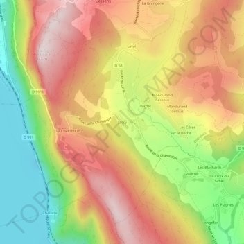
Name: Lassy topographic map, elevation, terrain.

Location: Lassy, Saint-Germain-la-Chambotte, Entrelacs, Chambéry, Savoie, Auvergne-Rhône-Alpes, France métropolitaine, 73410, France (45.75849 5.86794 45.79849 5.90794)

Average elevation: 1,778 ft

Minimum elevation: 702 ft

Maximum elevation: 2,733 ft

Other topographic maps

Click on a map to view its topography, its elevation and its terrain.

Albens

France > Auvergne-Rhône-Alpes > Savoie > Entrelacs

Average elevation: 1,480 ft

Épersy

France > Auvergne-Rhône-Alpes > Savoie > Entrelacs

Average elevation: 1,549 ft

73410

France > Auvergne-Rhône-Alpes > Savoie > Entrelacs

Average elevation: 1,552 ft

Saint-Girod

France > Auvergne-Rhône-Alpes > Savoie > Entrelacs

Average elevation: 1,417 ft

La Chambotte

France > Auvergne-Rhône-Alpes > Savoie > Entrelacs

Average elevation: 1,621 ft

Gear up for your next adventure:

🧣Merino Neck Gaiters - Multi-functional headwear for wind and sun protection
🪄Magnetic Compass - Accurate compass for navigation
GPS Sports Watch - GPS watch for running, hiking and training
🩹Survival Bandages - High‑quality bandages for emergencies
📦Gear Storage Bags - Organize and protect outdoor equipment

As an Amazon Associate, this site earns from qualifying purchases at no extra cost to you.