
Make a donation
Gear up for your next adventure:
As an Amazon Associate, this site earns from qualifying purchases at no extra cost to you.
Vlijtingen topographic map
Click on the map to display elevation.
Make a donation
Gear up for your next adventure:
As an Amazon Associate, this site earns from qualifying purchases at no extra cost to you.
Vlijtingen
Vlijtingen ligt in Droog-Haspengouw. Ondiepe droogdalen met zouwen die enkel nu en dan regenwater afvoeren zorgen voor een heuvelachtig landschap met zachte hellingen. De hoogte varieert van 80 tot 105 meter. De vruchtbare lössbodem wordt volledig bewerkt. Het landschap is dus open en heuvelachtig met karakteristieke kleine landschapselementen (holle wegen, taluds, graften) die in Vlijtingen dikwijls verdwenen zijn omdat de eerste ruilverkaveling van Vlaanderen vrij drastisch ingreep.
Make a donation
Gear up for your next adventure:
As an Amazon Associate, this site earns from qualifying purchases at no extra cost to you.
About this map
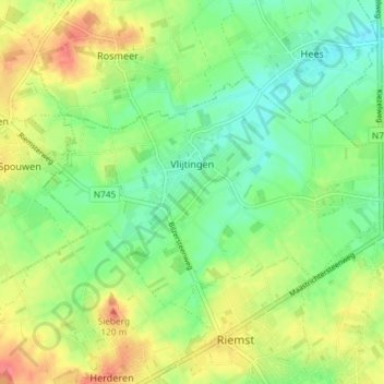
Name: Vlijtingen topographic map, elevation, terrain.
Location: Vlijtingen, Riemst, Tongeren, Limburg, België (50.81538 5.56108 50.84339 5.63433)
Average elevation: 315 ft
Minimum elevation: 236 ft
Maximum elevation: 427 ft
Make a donation
Gear up for your next adventure:
As an Amazon Associate, this site earns from qualifying purchases at no extra cost to you.
Other topographic maps
Click on a map to view its topography, its elevation and its terrain.