
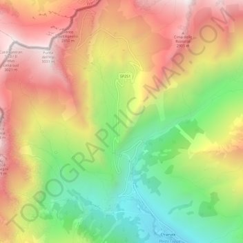
Gr. dell'Agnello topographic map
Interactive map
Click on the map to display elevation.
About this map
Name: Gr. dell'Agnello topographic map, elevation, terrain.
Location: Gr. dell'Agnello, Pontechianale, Coni, Piémont, Italie (44.64524 6.96794 44.68524 7.00794)
Average elevation: 7,874 ft
Minimum elevation: 5,827 ft
Maximum elevation: 9,911 ft
Other topographic maps
Click on a map to view its topography, its elevation and its terrain.
La Chenal
Italie > Piémont > Coni > Pontechianale
La Chenal, Pontechianale, Coni, Piémont, Italie
Average elevation: 7,293 ft
Castello
Italie > Piémont > Coni > Pontechianale
Castello, Pontechianale, Coni, Piémont, Italie
Average elevation: 6,237 ft
Fonte
Italie > Piémont > Coni > Pontechianale
Fonte, Monviso - via normale, Pontechianale, Coni, Piémont, Italie
Average elevation: 8,825 ft
Col Agnel
Italie > Piémont > Coni > Pontechianale
Col Agnel, Pontechianale, Coni, Piémont, Italie
Average elevation: 8,858 ft