
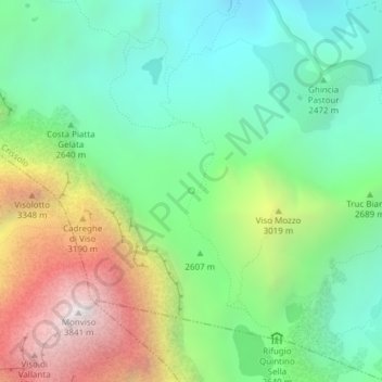
Fonte topographic map
Interactive map
Click on the map to display elevation.
About this map
Name: Fonte topographic map, elevation, terrain.
Average elevation: 8,825 ft
Minimum elevation: 6,867 ft
Maximum elevation: 12,569 ft
Other topographic maps
Click on a map to view its topography, its elevation and its terrain.
La Chenal
Italie > Piémont > Coni > Pontechianale
La Chenal, Pontechianale, Coni, Piémont, Italie
Average elevation: 7,293 ft
Gr. dell'Agnello
Italie > Piémont > Coni > Pontechianale
Gr. dell'Agnello, Pontechianale, Coni, Piémont, Italie
Average elevation: 7,874 ft
Castello
Italie > Piémont > Coni > Pontechianale
Castello, Pontechianale, Coni, Piémont, Italie
Average elevation: 6,237 ft
Col Agnel
Italie > Piémont > Coni > Pontechianale
Col Agnel, Pontechianale, Coni, Piémont, Italie
Average elevation: 8,858 ft