
Make a donation
Gear up for your next adventure:
As an Amazon Associate, this site earns from qualifying purchases at no extra cost to you.
Wellington topographic map
Click on the map to display elevation.
Make a donation
Gear up for your next adventure:
As an Amazon Associate, this site earns from qualifying purchases at no extra cost to you.
About this map
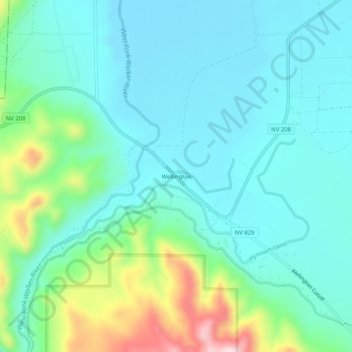
Name: Wellington topographic map, elevation, terrain.
Location: Wellington, Lyon County, Nevada, 89444, United States (38.73673 -119.39746 38.77673 -119.35746)
Average elevation: 4,997 ft
Minimum elevation: 4,770 ft
Maximum elevation: 5,787 ft
Lyon County trails, hiking, mountain biking, running and outdoor activities
Make a donation
Gear up for your next adventure:
As an Amazon Associate, this site earns from qualifying purchases at no extra cost to you.
Other topographic maps
Click on a map to view its topography, its elevation and its terrain.
Yerington
United States > Nevada > Lyon County
During the summer, temperatures are generally hot to very hot in the afternoon, but the high altitude and low humidity means temperature drop to a comfortable level at night. On average, 8.0 afternoons each summer will exceed 100 °F or 37.8 °C and 73.2 afternoons reach 90 °F (32.2 °C). It is rare, though,…
Average elevation: 4,455 ft