
Make a donation
Gear up for your next adventure:
As an Amazon Associate, this site earns from qualifying purchases at no extra cost to you.
Khorixas topographic map
Click on the map to display elevation.
Make a donation
Gear up for your next adventure:
As an Amazon Associate, this site earns from qualifying purchases at no extra cost to you.
Khorixas
The regional hospital and some other regional offices are still located in Khorixas, though the capital of Kunene Region is Opuwo. Khorixas has a landing strip nine kilometers east of town parallel to the main road C39. The Runway Numbers are 09/27 and elevation is 3320 feet.
Make a donation
Gear up for your next adventure:
As an Amazon Associate, this site earns from qualifying purchases at no extra cost to you.
About this map
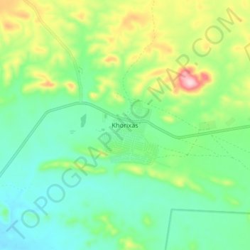
Name: Khorixas topographic map, elevation, terrain.
Location: Khorixas, Kunene Region, Namibia (-20.41384 14.92042 -20.33384 15.00042)
Average elevation: 3,196 ft
Minimum elevation: 2,943 ft
Maximum elevation: 3,770 ft
Make a donation
Gear up for your next adventure:
As an Amazon Associate, this site earns from qualifying purchases at no extra cost to you.