
Thank you for supporting this site ❤️
Make a donation
Make a donation
Gear up for your next adventure:
As an Amazon Associate, this site earns from qualifying purchases at no extra cost to you.
Hawālbāgh topographic map
Click on the map to display elevation.
Thank you for supporting this site ❤️
Make a donation
Make a donation
Gear up for your next adventure:
As an Amazon Associate, this site earns from qualifying purchases at no extra cost to you.
About this map
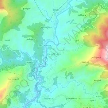
Name: Hawālbāgh topographic map, elevation, terrain.
Location: Hawālbāgh, Almora, Uttarakhand, 263601, India (29.62386 79.61303 29.66386 79.65303)
Average elevation: 4,209 ft
Minimum elevation: 3,707 ft
Maximum elevation: 5,676 ft
Thank you for supporting this site ❤️
Make a donation
Make a donation
Gear up for your next adventure:
As an Amazon Associate, this site earns from qualifying purchases at no extra cost to you.