Geolocate

Swynnerton topographic map

Click on the map to display elevation.

About this map

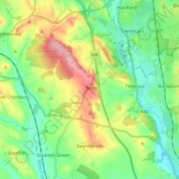
Name: Swynnerton topographic map, elevation, terrain.

Location: Swynnerton, Stafford, Staffordshire, England, United Kingdom (52.90122 -2.27802 52.98056 -2.18032)

Average elevation: 436 ft

Minimum elevation: 276 ft

Maximum elevation: 751 ft

Gear up for your next adventure:

📷Action Camera - Capture your outdoor adventures in HD
🦶Carbon Trekking Poles - Reduce knee impact on steep descents with ultra-light poles
🛡️Insect Repellent - Protection against bugs during outdoor activities
🧭Hiking Compass - Precision compass for reliable navigation in the wilderness
🥄Camping Utensil Set - Lightweight utensils for outdoor meals

As an Amazon Associate, this site earns from qualifying purchases at no extra cost to you.