
Ludwigshafen am Rhein topographic map
Click on the map to display elevation.
About this map
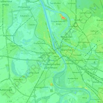
Name: Ludwigshafen am Rhein topographic map, elevation, terrain.
Location: Ludwigshafen am Rhein, Rhineland-Palatinate, Germany (49.42670 8.29822 49.54806 8.47694)
Average elevation: 315 ft
Minimum elevation: 272 ft
Maximum elevation: 459 ft
Other topographic maps
Click on a map to view its topography, its elevation and its terrain.
Queichhambach
Germany > Rhineland-Palatinate > Landkreis Südliche Weinstraße > Annweiler am Trifels
Average elevation: 837 ft
Eifel
Germany > Rhineland-Palatinate > Landkreis Ahrweiler > Adenau
The Eifel is in the Atlantic climate zone with its relatively high precipitation; winters that are moderately cold and long with periods of snow; and summers that are often humid and cool. The prevailing wind is west/southwest. A relatively dry and milder climate prevails in the wind and rain shadow of the…
Average elevation: 1,919 ft