
Make a donation
Gear up for your next adventure:
As an Amazon Associate, this site earns from qualifying purchases at no extra cost to you.
Mo’orea topographic map
Click on the map to display elevation.
Make a donation
Gear up for your next adventure:
As an Amazon Associate, this site earns from qualifying purchases at no extra cost to you.
Mo’orea
Many Moʼorean endemic species have gone extinct or been extirpated. The Polynesian tree snails of the genus Partula were largely wiped out after the rosy wolf snail was introduced in 1977, although captive and small refuge populations on Tahiti still exist. In 2019 both Partula rosea and Partula varia were reintroduced to the island. Until the 1980s, the Moʼorea reed warbler, an endemic species, was recorded on the island. This songbird was closely related to the Tahiti reed warbler and may have been displaced by the common myna. Another bird species extinct on Moʼorea is the Moʼorea sandpiper, of which only two specimens are known from 1777. The tree Glochidion nadeaudii is endemic to the island, growing in montane rain forests above 400 meters (1000 feet) elevation.
Make a donation
Gear up for your next adventure:
As an Amazon Associate, this site earns from qualifying purchases at no extra cost to you.
About this map
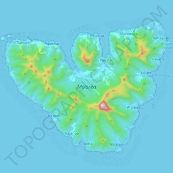
Name: Mo’orea topographic map, elevation, terrain.
Location: Mo’orea, Windward Islands, French Polynesia, France (-17.59336 -149.91594 -17.47326 -149.75258)
Average elevation: 282 ft
Minimum elevation: 0 ft
Maximum elevation: 3,944 ft
Make a donation
Gear up for your next adventure:
As an Amazon Associate, this site earns from qualifying purchases at no extra cost to you.
Other topographic maps
Click on a map to view its topography, its elevation and its terrain.
Mont Orohena
France > French Polynesia > Windward Islands > Māhina
Mont Orohena is a mountain located in the South Pacific, on the island of Tahiti. With an elevation of 2,241 metres (7,352 ft) above sea level, it is the highest point of French Polynesia. Mont Orohena is an extinct volcano and ranks 7th in the world for topographic isolation.
Average elevation: 4,206 ft
Make a donation
Gear up for your next adventure:
As an Amazon Associate, this site earns from qualifying purchases at no extra cost to you.
Make a donation
Gear up for your next adventure:
As an Amazon Associate, this site earns from qualifying purchases at no extra cost to you.
Make a donation
Gear up for your next adventure:
As an Amazon Associate, this site earns from qualifying purchases at no extra cost to you.
Make a donation
Gear up for your next adventure:
As an Amazon Associate, this site earns from qualifying purchases at no extra cost to you.
Make a donation
Gear up for your next adventure:
As an Amazon Associate, this site earns from qualifying purchases at no extra cost to you.
Make a donation
Gear up for your next adventure:
As an Amazon Associate, this site earns from qualifying purchases at no extra cost to you.
Make a donation
Gear up for your next adventure:
As an Amazon Associate, this site earns from qualifying purchases at no extra cost to you.
Make a donation
Gear up for your next adventure:
As an Amazon Associate, this site earns from qualifying purchases at no extra cost to you.
Fatu Huku
France > French Polynesia > Marquesas Islands > Hiva Oa
The island is essentially a huge rock, looming steep-sided out of the ocean and rising to a flattened plateau with a maximum elevation of 361 metres (1,184 ft). Fatu Huku is the youngest of the volcanic Marquesas Islands, estimated to be only 1.3 million years old which accounts, in part, for its ruggedness as…
Average elevation: 26 ft
Make a donation
Gear up for your next adventure:
As an Amazon Associate, this site earns from qualifying purchases at no extra cost to you.
Make a donation
Gear up for your next adventure:
As an Amazon Associate, this site earns from qualifying purchases at no extra cost to you.
Make a donation
Gear up for your next adventure:
As an Amazon Associate, this site earns from qualifying purchases at no extra cost to you.
Make a donation
Gear up for your next adventure:
As an Amazon Associate, this site earns from qualifying purchases at no extra cost to you.
Make a donation
Gear up for your next adventure:
As an Amazon Associate, this site earns from qualifying purchases at no extra cost to you.