
Make a donation
Gear up for your next adventure:
As an Amazon Associate, this site earns from qualifying purchases at no extra cost to you.
Guarapuava topographic map
Click on the map to display elevation.
Make a donation
Gear up for your next adventure:
As an Amazon Associate, this site earns from qualifying purchases at no extra cost to you.
Guarapuava
Guarapuava is located at 25°23'36" S and 51°27'19" W. The region is known as the centre of the state of Paraná, in the third plateau, also called the Plateau of Guarapuava. Discovered by the Portuguese in 1770, and founded in 1810, the city's name derives from tupi guarani, meaning place of Maned wolves sound (Maned wolves are called lobos-guará in Portuguese). Its elevation is 1120 m (3675 ft).
Make a donation
Gear up for your next adventure:
As an Amazon Associate, this site earns from qualifying purchases at no extra cost to you.
About this map
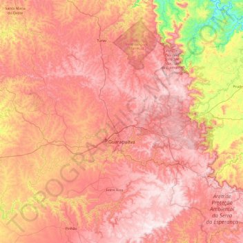
Name: Guarapuava topographic map, elevation, terrain.
Average elevation: 3,284 ft
Minimum elevation: 1,608 ft
Maximum elevation: 4,446 ft
Make a donation
Gear up for your next adventure:
As an Amazon Associate, this site earns from qualifying purchases at no extra cost to you.
Other topographic maps
Click on a map to view its topography, its elevation and its terrain.
Curitiba
Brazil > Paraná > Região Metropolitana de Curitiba
The city covers 432.17 km2 (166.86 sq mi) on the First Plateau of Paraná. Curitiba has a topography of smooth, rounded hills, giving it a relatively regular shape. The city has an average altitude of 934.6 m (3,066 ft) above sea level. The highest point is to the north at 1,021 m (3,350 ft), and with lower…
Average elevation: 3,054 ft
Make a donation
Gear up for your next adventure:
As an Amazon Associate, this site earns from qualifying purchases at no extra cost to you.
Bosque Gutierrez
Brazil > Paraná > Região Metropolitana de Curitiba > Curitiba
Average elevation: 3,084 ft
Itaipu Dam
Brazil > Paraná > Foz do Iguaçu
325 metres (1,066 ft), entire dam including the 100 metres (330 ft) high Power Line 4 Pylons atop the Barrage 260 metres (850 ft), dam + the foundation inside water until the river floor 247 metres (810 ft), 196 metres (643 ft) high of roof reinforcement concrete dam + Cranes atop the Barrage 225 metres (738…
Average elevation: 630 ft
Make a donation
Gear up for your next adventure:
As an Amazon Associate, this site earns from qualifying purchases at no extra cost to you.
Curitiba
Brazil > Paraná > Região Metropolitana de Curitiba
The city covers 432.17 km2 (166.86 sq mi) on the First Plateau of Paraná. Curitiba has a topography of smooth, rounded hills, giving it a relatively regular shape. The city has an average altitude of 934.6 m (3,066 ft) above sea level. The highest point is to the north at 1,021 m (3,350 ft), and with lower…
Average elevation: 3,054 ft
Make a donation
Gear up for your next adventure:
As an Amazon Associate, this site earns from qualifying purchases at no extra cost to you.
Southern carcara
Brazil > Paraná > Região Metropolitana de Curitiba > Curitiba
Average elevation: 2,884 ft
Make a donation
Gear up for your next adventure:
As an Amazon Associate, this site earns from qualifying purchases at no extra cost to you.
Make a donation
Gear up for your next adventure:
As an Amazon Associate, this site earns from qualifying purchases at no extra cost to you.
Tijucas do Sul
Brazil > Paraná > Região Metropolitana de Curitiba > Tijucas do Sul > Tijucas do Sul
Average elevation: 2,995 ft
Make a donation
Gear up for your next adventure:
As an Amazon Associate, this site earns from qualifying purchases at no extra cost to you.