Geolocate

Urgezes topographic map

Click on the map to display elevation.

About this map

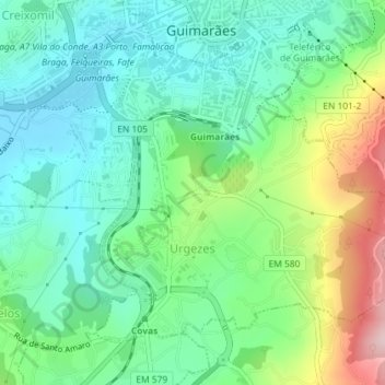
Name: Urgezes topographic map, elevation, terrain.

Location: Urgezes, Guimarães, Braga, Portugal (41.41995 -8.30547 41.44076 -8.27746)

Average elevation: 764 ft

Minimum elevation: 486 ft

Maximum elevation: 1,427 ft

Other topographic maps

Click on a map to view its topography, its elevation and its terrain.

Guimarães

Portugal > Braga > Guimarães

Average elevation: 981 ft

Além

Portugal > Braga > Guimarães > Sande (Vila Nova)

Average elevation: 472 ft

Gear up for your next adventure:

🌲Outdoor Survival Books - Best books on survival skills
📖Nature Tracking Books - Learn to track wildlife and terrain
🧼Biodegradable Camping Soap - Eco‑friendly soap for outdoor hygiene
🩳Quick‑Dry Hiking Shorts - Comfortable and quick‑dry shorts for summer hiking
🔥Plasma Lighters - Windproof lighters that work in any weather condition

As an Amazon Associate, this site earns from qualifying purchases at no extra cost to you.