
Thank you for supporting this site ❤️
Make a donation
Make a donation
Gear up for your next adventure:
As an Amazon Associate, this site earns from qualifying purchases at no extra cost to you.
Martogna topographic map
Click on the map to display elevation.
Thank you for supporting this site ❤️
Make a donation
Make a donation
Gear up for your next adventure:
As an Amazon Associate, this site earns from qualifying purchases at no extra cost to you.
About this map
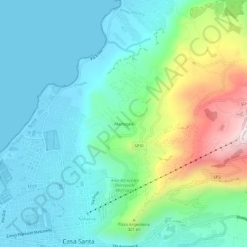
Name: Martogna topographic map, elevation, terrain.
Location: Martogna, Casa Santa, Erice, Trapani, Sicilia, 91016, Italia (38.01886 12.53873 38.05886 12.57873)
Average elevation: 587 ft
Minimum elevation: -7 ft
Maximum elevation: 2,375 ft
Thank you for supporting this site ❤️
Make a donation
Make a donation
Gear up for your next adventure:
As an Amazon Associate, this site earns from qualifying purchases at no extra cost to you.