
六盘山镇 topographic map
Interactive map
Click on the map to display elevation.
About this map
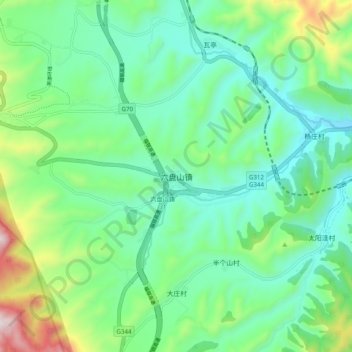
Name: 六盘山镇 topographic map, elevation, terrain.
Location: 六盘山镇, 泾源县, 固原市, 宁夏回族自治区, 中国 (35.62349 106.24717 35.70349 106.32717)
Average elevation: 6,539 ft
Minimum elevation: 5,846 ft
Maximum elevation: 8,514 ft
Other topographic maps
Click on a map to view its topography, its elevation and its terrain.