Geolocate

Dithmarschen topographic map

Click on the map to display elevation.

About this map

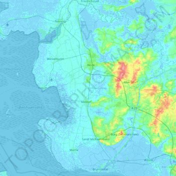
Name: Dithmarschen topographic map, elevation, terrain.

Location: Dithmarschen, Schleswig-Holstein, Germany (53.87754 8.67970 54.37878 9.44437)

Average elevation: 16 ft

Minimum elevation: -16 ft

Maximum elevation: 249 ft

Other topographic maps

Click on a map to view its topography, its elevation and its terrain.

Stellau

Germany > Schleswig-Holstein > Stormarn > Barsbüttel

Average elevation: 171 ft

Gear up for your next adventure:

🪓Survival Multi‑Tool - Versatile tool for camp and trail tasks
🩹Survival Bandages - High‑quality bandages for emergencies
🔥Plasma Lighters - Windproof lighters that work in any weather condition
👟Trail Running Shoes - Lightweight shoes for trail runners
🧷Carabiner Set - Durable clips for gear attachment

As an Amazon Associate, this site earns from qualifying purchases at no extra cost to you.