
Make a donation
Gear up for your next adventure:
As an Amazon Associate, this site earns from qualifying purchases at no extra cost to you.
Karsdorf topographic map
Click on the map to display elevation.
Make a donation
Gear up for your next adventure:
As an Amazon Associate, this site earns from qualifying purchases at no extra cost to you.
Karsdorf
Karsdorf ist ein etwa ein Kilometer langes Waldhufendorf, das sich in südwestliche Richtung vom Höhenrücken der Karsdorfer Verwerfung (Quohrener Kipse, 452 Meter) zum Oelsabach hinunter erstreckt. Durch das obere Ortsende führt die Bundesstraße 170, von der die Dorfstraße abzweigt. Der Ort liegt auf etwa 350 Metern Meereshöhe und befindet sich am untersten Ende des Osterzgebirges.
Make a donation
Gear up for your next adventure:
As an Amazon Associate, this site earns from qualifying purchases at no extra cost to you.
About this map
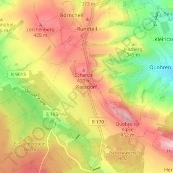
Name: Karsdorf topographic map, elevation, terrain.
Average elevation: 1,178 ft
Minimum elevation: 823 ft
Maximum elevation: 1,473 ft
Make a donation
Gear up for your next adventure:
As an Amazon Associate, this site earns from qualifying purchases at no extra cost to you.