
Thank you for supporting this site ❤️
Make a donation
Make a donation
Gear up for your next adventure:
As an Amazon Associate, this site earns from qualifying purchases at no extra cost to you.
Carnizza topographic map
Click on the map to display elevation.
Thank you for supporting this site ❤️
Make a donation
Make a donation
Gear up for your next adventure:
As an Amazon Associate, this site earns from qualifying purchases at no extra cost to you.
About this map
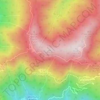
Name: Carnizza topographic map, elevation, terrain.
Location: Carnizza, Faedis, Udine, Friuli-Venezia Giulia, 33040, Italia (46.18740 13.36980 46.18750 13.36990)
Average elevation: 2,411 ft
Minimum elevation: 1,125 ft
Maximum elevation: 3,258 ft
Thank you for supporting this site ❤️
Make a donation
Make a donation
Gear up for your next adventure:
As an Amazon Associate, this site earns from qualifying purchases at no extra cost to you.