
Lanoraie topographic map
Interactive map
Click on the map to display elevation.
About this map
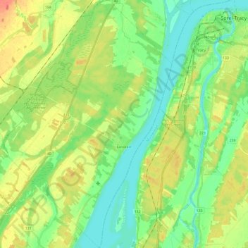
Name: Lanoraie topographic map, elevation, terrain.
Location: Lanoraie, D'Autray, Lanaudière, Quebec, J0K 1E0, Canada (45.89310 -73.33237 46.05506 -73.17464)
Average elevation: 59 ft
Minimum elevation: 0 ft
Maximum elevation: 148 ft
Other topographic maps
Click on a map to view its topography, its elevation and its terrain.
Mandeville
Mandeville, D'Autray, Lanaudière, Quebec, J0K 1L0, Canada
Average elevation: 1,115 ft
Berthierville
Berthierville, D'Autray, Lanaudière, Quebec, J0K 1A0, Canada
Average elevation: 30 ft
Saint-Gabriel
Saint-Gabriel, D'Autray, Lanaudière, Quebec, J0K 2N0, Canada
Average elevation: 541 ft
Saint-Cuthbert
Saint-Cuthbert, D'Autray, Lanaudière, Quebec, J0K 2C0, Canada
Average elevation: 302 ft
Saint-Gabriel-de-Brandon
Canada > Quebec > D'Autray > Saint-Gabriel
Saint-Gabriel-de-Brandon, Saint-Gabriel, D'Autray, Lanaudière, Quebec, J0K 2N0, Canada
Average elevation: 614 ft
Saint-Barthélemy
Canada > Quebec > D'Autray > Saint-Barthélemy
Saint-Barthélemy, D'Autray, Lanaudière, Quebec, J0K 1X0, Canada
Average elevation: 197 ft
Saint-Ignace-de-Loyola
Saint-Ignace-de-Loyola, D'Autray, Lanaudière, Quebec, J0K 2P0, Canada
Average elevation: 36 ft