
Make a donation
Gear up for your next adventure:
As an Amazon Associate, this site earns from qualifying purchases at no extra cost to you.
Inzigkofen topographic map
Click on the map to display elevation.
Make a donation
Gear up for your next adventure:
As an Amazon Associate, this site earns from qualifying purchases at no extra cost to you.
About this map
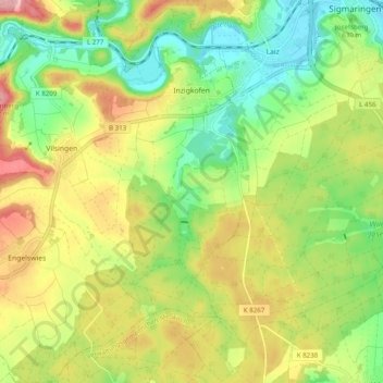
Name: Inzigkofen topographic map, elevation, terrain.
Average elevation: 2,100 ft
Minimum elevation: 1,867 ft
Maximum elevation: 2,405 ft
Make a donation
Gear up for your next adventure:
As an Amazon Associate, this site earns from qualifying purchases at no extra cost to you.
Other topographic maps
Click on a map to view its topography, its elevation and its terrain.
Inneringen
Germany > Baden-Württemberg > Landkreis Sigmaringen > Hettingen
Average elevation: 2,579 ft
Steinbronnen
Germany > Baden-Württemberg > Landkreis Sigmaringen > Bad Saulgau > Bierstetten
Average elevation: 2,093 ft
Schnerkingen
Germany > Baden-Württemberg > Landkreis Sigmaringen > Meßkirch
Average elevation: 2,080 ft
Make a donation
Gear up for your next adventure:
As an Amazon Associate, this site earns from qualifying purchases at no extra cost to you.