
Make a donation
Gear up for your next adventure:
As an Amazon Associate, this site earns from qualifying purchases at no extra cost to you.
Alcorcón topographic map
Click on the map to display elevation.
Make a donation
Gear up for your next adventure:
As an Amazon Associate, this site earns from qualifying purchases at no extra cost to you.
Alcorcón
The municipality, largely flat, lies at an average altitude of 711 metres above sea level, with the highest point being El Ventorro del Cano (741 m), located in the north of the municipality.
Make a donation
Gear up for your next adventure:
As an Amazon Associate, this site earns from qualifying purchases at no extra cost to you.
About this map
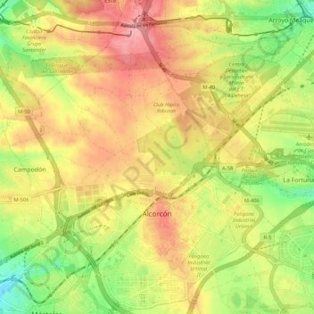
Name: Alcorcón topographic map, elevation, terrain.
Location: Alcorcón, Community of Madrid, Spain (40.32394 -3.87879 40.40310 -3.78792)
Average elevation: 2,270 ft
Minimum elevation: 2,080 ft
Maximum elevation: 2,434 ft
Make a donation
Gear up for your next adventure:
As an Amazon Associate, this site earns from qualifying purchases at no extra cost to you.
Other topographic maps
Click on a map to view its topography, its elevation and its terrain.