
Make a donation
Gear up for your next adventure:
As an Amazon Associate, this site earns from qualifying purchases at no extra cost to you.
Vivegnis topographic map
Click on the map to display elevation.
Make a donation
Gear up for your next adventure:
As an Amazon Associate, this site earns from qualifying purchases at no extra cost to you.
Vivegnis
Vivegnis ligt aan het Albertkanaal op een hoogte van ongeveer 100 meter, tegenover het langgerekte schiereiland dat zich tussen dit kanaal en de Maas bevindt. Vroeger bekend om zijn wijngaarden en fruitteelt, is de plaats tegenwoordig vooral industrieel van karakter.
Make a donation
Gear up for your next adventure:
As an Amazon Associate, this site earns from qualifying purchases at no extra cost to you.
About this map
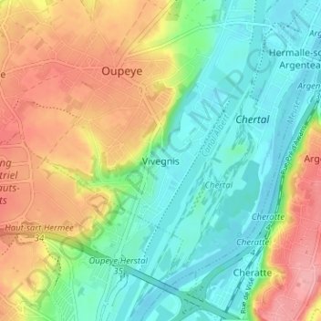
Name: Vivegnis topographic map, elevation, terrain.
Location: Vivegnis, Oupeye, Luik, Wallonië, 4680, België (50.67793 5.63271 50.71793 5.67271)
Average elevation: 308 ft
Minimum elevation: 174 ft
Maximum elevation: 509 ft
Make a donation
Gear up for your next adventure:
As an Amazon Associate, this site earns from qualifying purchases at no extra cost to you.