
Thank you for supporting this site ❤️
Make a donation
Make a donation
Gear up for your next adventure:
As an Amazon Associate, this site earns from qualifying purchases at no extra cost to you.
Trasenster topographic map
Click on the map to display elevation.
Thank you for supporting this site ❤️
Make a donation
Make a donation
Gear up for your next adventure:
As an Amazon Associate, this site earns from qualifying purchases at no extra cost to you.
About this map
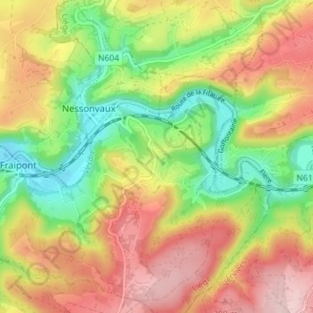
Name: Trasenster topographic map, elevation, terrain.
Location: Trasenster, Nessonvaux, Trooz, Luik, Wallonië, 4870, België (50.54748 5.73066 50.58748 5.77066)
Average elevation: 682 ft
Minimum elevation: 318 ft
Maximum elevation: 1,056 ft
Thank you for supporting this site ❤️
Make a donation
Make a donation
Gear up for your next adventure:
As an Amazon Associate, this site earns from qualifying purchases at no extra cost to you.