
Make a donation
Gear up for your next adventure:
As an Amazon Associate, this site earns from qualifying purchases at no extra cost to you.
Costedt topographic map
Click on the map to display elevation.
Make a donation
Gear up for your next adventure:
As an Amazon Associate, this site earns from qualifying purchases at no extra cost to you.
About this map
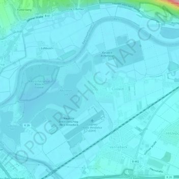
Name: Costedt topographic map, elevation, terrain.
Average elevation: 171 ft
Minimum elevation: 121 ft
Maximum elevation: 840 ft
Make a donation
Gear up for your next adventure:
As an Amazon Associate, this site earns from qualifying purchases at no extra cost to you.
Other topographic maps
Click on a map to view its topography, its elevation and its terrain.
Kleinenbremen
Deutschland > Nordrhein-Westfalen > Kreis Minden-Lübbecke > Porta Westfalica
Average elevation: 430 ft
Porta Westfalica
Deutschland > Nordrhein-Westfalen > Kreis Minden-Lübbecke > Porta Westfalica
Average elevation: 262 ft
Barksen
Deutschland > Nordrhein-Westfalen > Kreis Minden-Lübbecke > Porta Westfalica
Average elevation: 453 ft
Vennebeck
Deutschland > Nordrhein-Westfalen > Kreis Minden-Lübbecke > Porta Westfalica
Average elevation: 190 ft
Make a donation
Gear up for your next adventure:
As an Amazon Associate, this site earns from qualifying purchases at no extra cost to you.
Vennebeckerbruch
Deutschland > Nordrhein-Westfalen > Kreis Minden-Lübbecke > Porta Westfalica
Average elevation: 282 ft