Geolocate

Central topographic map

Click on the map to display elevation.

About this map

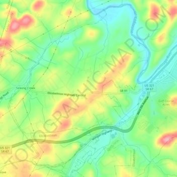
Name: Central topographic map, elevation, terrain.

Location: Central, Carter County, East Tennessee, Tennessee, United States (36.30839 -82.32075 36.34708 -82.27008)

Average elevation: 1,604 ft

Minimum elevation: 1,430 ft

Maximum elevation: 1,850 ft

Carter County trails, hiking, mountain biking, running and outdoor activities

Other topographic maps

Click on a map to view its topography, its elevation and its terrain.

Elizabethton

United States > Tennessee > Carter County > Elizabethton > Elizabethton

The elevation at Elizabethton Municipal Airport is 1,593 feet (486 m) ASL (the highest point of elevation in Carter County is at Roan Mountain with an elevation of 6,285 feet (1,916 m) ASL), and the airport is located on the eastern side of the city along State Highway 91 Stoney Creek Exit. Elizabethton is…

Average elevation: 1,729 ft

Rayon Terrace

United States > Tennessee > Carter County > Elizabethton

Average elevation: 1,713 ft

Burbank

United States > Tennessee > Carter County

Average elevation: 3,369 ft

Buladeen

United States > Tennessee > Carter County

Average elevation: 2,595 ft

Elk Mills

United States > Tennessee > Carter County

Average elevation: 2,457 ft

Roan Mountain State Park

United States > Tennessee > Carter County > Roan Mountain

Roan Mountain State Park hosts a variety of outdoor activities including hiking, mountain biking, camping, cross-country skiing (during snowy, winter months), fishing, and swimming. A heated swimming pool is open from Memorial Day to mid-August. At an elevation of 2,972 feet (906 m), the outdoor swimming pool…

Average elevation: 3,241 ft

Winner

United States > Tennessee > Carter County

Average elevation: 2,014 ft

Tolley Town

United States > Tennessee > Carter County

Average elevation: 2,940 ft

Gap Run

United States > Tennessee > Carter County

Average elevation: 2,457 ft

Milligan

United States > Tennessee > Carter County > Elizabethton > Milligan

Average elevation: 1,667 ft

Jane Bald

United States > Tennessee > Carter County

Average elevation: 5,161 ft

Dogtown

United States > Tennessee > Carter County

Average elevation: 2,024 ft

Gear up for your next adventure:

🗻Climbing Gear Basics - Essential gear for beginner climbers
🪶Wildlife Field Guides - Learn animal tracking and species ID
🧭Orienteering Set - Complete compass and map reading kit
🔭Telescopic Hiking Pole - Adjustable pole for hiking stability
🎒Day Hiking Backpack - Lightweight backpack perfect for day trips and outdoor adventures

As an Amazon Associate, this site earns from qualifying purchases at no extra cost to you.