
Obulapuram topographic map
Interactive map
Click on the map to display elevation.
About this map
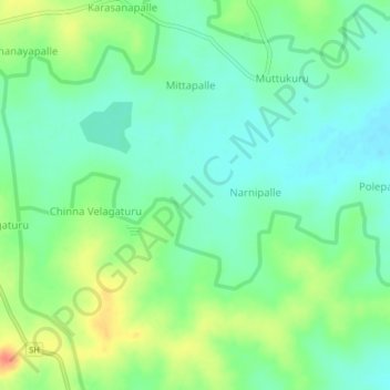
Name: Obulapuram topographic map, elevation, terrain.
Location: Obulapuram, Peddapanjani, Chittoor, Andhra Pradesh, India (13.25364 78.59822 13.29364 78.63822)
Average elevation: 2,336 ft
Minimum elevation: 2,277 ft
Maximum elevation: 2,448 ft
Other topographic maps
Click on a map to view its topography, its elevation and its terrain.
Obulapuram
India > Andhra Pradesh > Obulapuram
Obulapuram, Bathalapalle, Anantapur, Andhra Pradesh, India
Average elevation: 1,070 ft
Obulapuram
India > Andhra Pradesh > Obulapuram
Obulapuram, Prakasam, Andhra Pradesh, 523367, India
Average elevation: 906 ft