Geolocate

Biñan topographic map

Click on the map to display elevation.

About this map

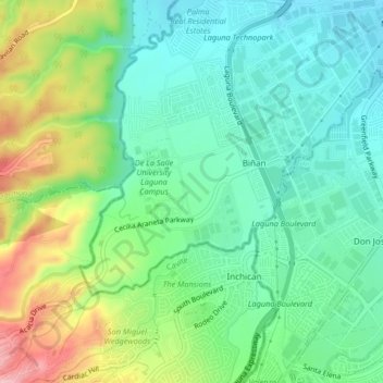
Name: Biñan topographic map, elevation, terrain.

Location: Biñan, Laguna, Calabarzon, 4024, Philippines (14.23989 121.02709 14.27989 121.06709)

Average elevation: 331 ft

Minimum elevation: 148 ft

Maximum elevation: 715 ft

Gear up for your next adventure:

🌧️Backpack Rain Cover - Keep gear dry in wet weather
🔦Compact Flashlight - Reliable flashlight for emergencies
🛌Ultralight Sleeping Bags - Compact down bags for cold nights in the wilderness
🔥Camping Stove - Portable stove for camping and backcountry cooking
👖Convertible Hiking Pants - Versatile zip-off pants for changing altitudes and temperatures

As an Amazon Associate, this site earns from qualifying purchases at no extra cost to you.