Geolocate

Khangral topographic map

Click on the map to display elevation.

About this map

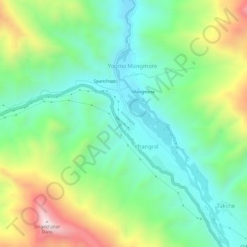
Name: Khangral topographic map, elevation, terrain.

Location: Khangral, Kargil Tehsil, Kargil district, Ladakh, India (34.35393 76.50695 34.39393 76.54695)

Average elevation: 11,932 ft

Minimum elevation: 11,063 ft

Maximum elevation: 13,668 ft

Gear up for your next adventure:

Backpacking Tent - Lightweight and durable tent for multi‑day hikes
🔊Portable Camp Speaker - Music and alerts at camp
🔌USB Car Charger - Car charger for on‑the‑go power needs
🛡️Bear Spray Outdoor - Protection in bear country hikes
🎒Trail Energy Bars - High‑calorie bars for hiking energy

As an Amazon Associate, this site earns from qualifying purchases at no extra cost to you.