Geolocate

Strathalbyn topographic map

Click on the map to display elevation.

About this map

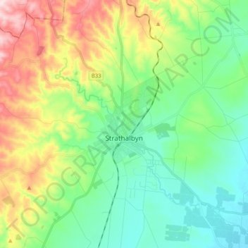
Name: Strathalbyn topographic map, elevation, terrain.

Location: Strathalbyn, Alexandrina Council, South Australia, 5255, Australia (-35.31106 138.78927 -35.18989 138.94712)

Average elevation: 430 ft

Minimum elevation: 82 ft

Maximum elevation: 1,165 ft

Other topographic maps

Click on a map to view its topography, its elevation and its terrain.

Goolwa

Australia > South Australia > Alexandrina Council > Goolwa

Average elevation: 30 ft

Gear up for your next adventure:

🕶️GPS Smartphone Mount - Secure mount for phone navigation
🔥Plasma Lighters - Windproof lighters that work in any weather condition
🔪Outdoor Multitools - Essential survival tools for gear repair and field use
🥘Titanium Cookware - Durable, featherlight pots and pans for backpacking
GPS Sports Watch - GPS watch for running, hiking and training

As an Amazon Associate, this site earns from qualifying purchases at no extra cost to you.