
Make a donation
Gear up for your next adventure:
As an Amazon Associate, this site earns from qualifying purchases at no extra cost to you.
Liebenburg topographic map
Click on the map to display elevation.
Make a donation
Gear up for your next adventure:
As an Amazon Associate, this site earns from qualifying purchases at no extra cost to you.
Liebenburg
Liebenburg liegt am östlichen Rand des südlichen Salzgitter-Höhenzugs im nördlichen Harzvorland zwischen Salzgitter-Bad und Schladen-Werla am 210 m hohen Burgberg. Durch den Ort fließt der Stobenbergbach, ein Nebenbach der Warne. Die nächstgelegenen Städte sind Goslar, Salzgitter und Wolfenbüttel.
Make a donation
Gear up for your next adventure:
As an Amazon Associate, this site earns from qualifying purchases at no extra cost to you.
About this map
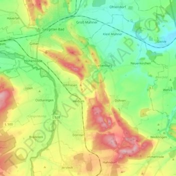
Name: Liebenburg topographic map, elevation, terrain.
Average elevation: 568 ft
Minimum elevation: 295 ft
Maximum elevation: 1,017 ft
Make a donation
Gear up for your next adventure:
As an Amazon Associate, this site earns from qualifying purchases at no extra cost to you.