Geolocate

Defiance topographic map

Click on the map to display elevation.

About this map

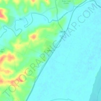
Name: Defiance topographic map, elevation, terrain.

Location: Defiance, Saint Charles County, Missouri, United States (38.61297 -90.79887 38.65297 -90.75887)

Average elevation: 502 ft

Minimum elevation: 449 ft

Maximum elevation: 676 ft

Saint Charles County trails, hiking, mountain biking, running and outdoor activities

Other topographic maps

Click on a map to view its topography, its elevation and its terrain.

Augusta

United States > Missouri > Saint Charles County > Augusta

Average elevation: 505 ft

Defiance

United States > Missouri > Saint Charles County

Average elevation: 499 ft

Saint Paul

United States > Missouri > Saint Charles County

Average elevation: 515 ft

Gear up for your next adventure:

🧭Outdoor Navigation Book - Learn advanced navigation skills
🗺️Topographic Maps - Detailed topo maps for hiking, exploring and outdoor navigation
🧤Tactile Hiking Gloves - Keep hands warm while operating GPS and smartphone screens
🌲Outdoor Survival Books - Best books on survival skills
🎁Geography Themed Gifts - Unique gift ideas for map lovers and geography enthusiasts

As an Amazon Associate, this site earns from qualifying purchases at no extra cost to you.