Geolocate

Coquille topographic map

Click on the map to display elevation.

About this map

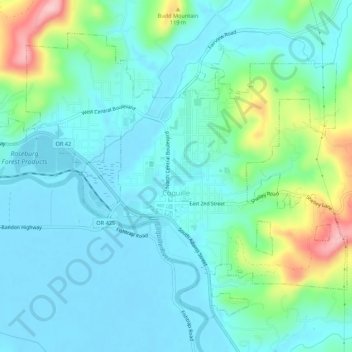
Name: Coquille topographic map, elevation, terrain.

Location: Coquille, Coos County, Oregon, United States (43.16283 -124.21542 43.19499 -124.16128)

Average elevation: 131 ft

Minimum elevation: -16 ft

Maximum elevation: 610 ft

Coos County trails, hiking, mountain biking, running and outdoor activities

Other topographic maps

Click on a map to view its topography, its elevation and its terrain.

Englewood

United States > Oregon > Coos County > Coos Bay

Average elevation: 135 ft

Sitkum

United States > Oregon > Coos County

Average elevation: 1,102 ft

Charleston

United States > Oregon > Coos County

Average elevation: 79 ft

Bullards

United States > Oregon > Coos County

Average elevation: 30 ft

Randolph

United States > Oregon > Coos County

Average elevation: 118 ft

Lampa Mountain

United States > Oregon > Coos County

Average elevation: 358 ft

Sitkum

United States > Oregon > Coos County

Average elevation: 1,102 ft

Whiskey Run Beach

United States > Oregon > Coos County

Average elevation: 72 ft

Gear up for your next adventure:

🌄Hiking Binoculars - Compact binoculars for scenic views and trail spotting
🧦Hiking Socks - Comfortable socks to prevent blisters on long hikes
🛡️Bear Spray Outdoor - Protection in bear country hikes
🛠️Outdoor Gear Repair Kit - Essential tools to fix gear on the trail
🧦Merino Wool Socks - Moisture-wicking, blister-preventing socks for long treks

As an Amazon Associate, this site earns from qualifying purchases at no extra cost to you.