Geolocate

Atpadi topographic map

Click on the map to display elevation.

About this map

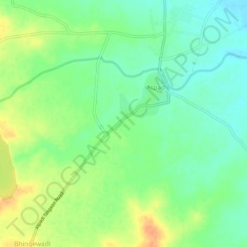
Name: Atpadi topographic map, elevation, terrain.

Location: Atpadi, Sangli District, Maharashtra, 415300, India (17.40294 74.91912 17.44294 74.95912)

Average elevation: 1,837 ft

Minimum elevation: 1,788 ft

Maximum elevation: 1,900 ft

Gear up for your next adventure:

📱Solar Portable Charger - Solar power bank for charging devices off‑grid
🕶️Glacier Sunglasses - Side shields to protect eyes from high-altitude snow glare
🏕️Family Camping Gear - Essentials for group camping trips
🪶Thermal Camp Blanket - Extra warmth for cold nights
🧭Compass with Lanyard - Easy‑carry compass for navigation

As an Amazon Associate, this site earns from qualifying purchases at no extra cost to you.