
Make a donation
Gear up for your next adventure:
As an Amazon Associate, this site earns from qualifying purchases at no extra cost to you.
Christiansted topographic map
Click on the map to display elevation.
Make a donation
Gear up for your next adventure:
As an Amazon Associate, this site earns from qualifying purchases at no extra cost to you.
About this map
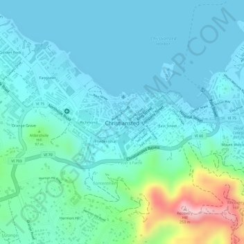
Name: Christiansted topographic map, elevation, terrain.
Average elevation: 148 ft
Minimum elevation: 0 ft
Maximum elevation: 807 ft
Saint Croix District trails, hiking, mountain biking, running and outdoor activities
Make a donation
Gear up for your next adventure:
As an Amazon Associate, this site earns from qualifying purchases at no extra cost to you.
Other topographic maps
Click on a map to view its topography, its elevation and its terrain.
Prospect Hill
United States > United States Virgin Islands > Saint Croix District
Average elevation: 361 ft
Morningstar
United States > United States Virgin Islands > Saint Croix District > Morningstar
Average elevation: 223 ft
Cartlon South
United States > United States Virgin Islands > Saint Croix District > Cartlon South
Average elevation: 75 ft
Longford (Anna's Hope Village)
United States > United States Virgin Islands > Saint Croix District
Average elevation: 161 ft
Make a donation
Gear up for your next adventure:
As an Amazon Associate, this site earns from qualifying purchases at no extra cost to you.