
Make a donation
Gear up for your next adventure:
As an Amazon Associate, this site earns from qualifying purchases at no extra cost to you.
Bafoussam topographic map
Click on the map to display elevation.
Make a donation
Gear up for your next adventure:
As an Amazon Associate, this site earns from qualifying purchases at no extra cost to you.
Bafoussam
Köppen-Geiger climate classification system classifies its climate as tropical savanna climate (Aw). However, its temperatures are lower than other locations with this classification due to its high elevation.
Make a donation
Gear up for your next adventure:
As an Amazon Associate, this site earns from qualifying purchases at no extra cost to you.
About this map
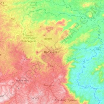
Name: Bafoussam topographic map, elevation, terrain.
Location: Bafoussam, Bafoussam I, Mifi, Cameroon (5.31588 10.26179 5.63588 10.58179)
Average elevation: 4,236 ft
Minimum elevation: 3,222 ft
Maximum elevation: 5,669 ft
Make a donation
Gear up for your next adventure:
As an Amazon Associate, this site earns from qualifying purchases at no extra cost to you.